Tag: History. Bribie Island. Queensland. Australia.
BRIBIE ISLAND’S FASCINATING HISTORY
BARRY CLARK – FOUNDING PRESIDENT, BRIBIE ISLAND HISTORICAL SOCIETY // IMAGES: BARRY CLARK & JOHN OXLEY LIBRARY
Bribie Island has many remarkable and often surprising secrets to reveal… if you know where to look.
When James Cook sailed past this coastline in 1770, he observed the far distant hills and named them “Glasshouses”, reminding him of Glass-Works in his distant homeland. When Matthew Flinders and his aboriginal companion Bongaree came exploring almost 30 years later in 1799, he was the first European to set foot on what is now Bribie Island.
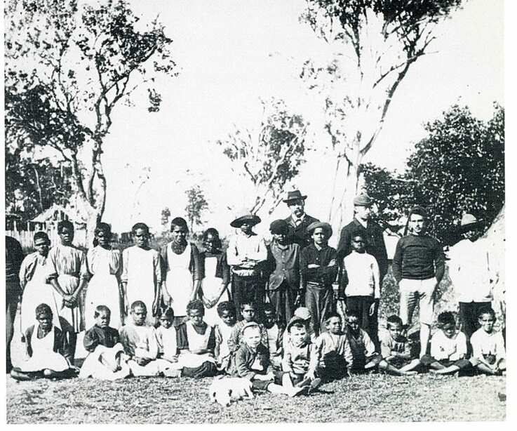
Featured image(above): School children at Mission Point, Bribie Island, being relocated to Stradbroke Island 1892. Possibly the very first photograph ever taken on Bribie Island.
Flinders travelled up what he called the Pumicestone River, and climbed one of the Glasshouse Mountains. Over the next 50 years, there were very few who came to this remote island and little trace can be found, other than surveyors marks and evidence of the long aboriginal occupation. In 1823 three castaway convicts spent several months with the local aboriginal people and were fortunate to be rescued on the island by those searching for a new penal colony site.
The worst of the worst convicts from Sydney were initially sent to a new penal settlement at Redcliffe in 1824, but this was relocated within a few months to a new and better site on the Brisbane River. It would be another 35 years before the State of Queensland was declared when separated from NSW in 1859.
During all those years there were still very few white men who came to this desolate island. Within a hundred years of the first sighting of these shores by Captain Cook, the once extensive Aboriginal population of Moreton Bay had been reduced to just a few. This led to the establishment of the first Aboriginal reserve right here on Bribie Island at Whitepatch in 1877.

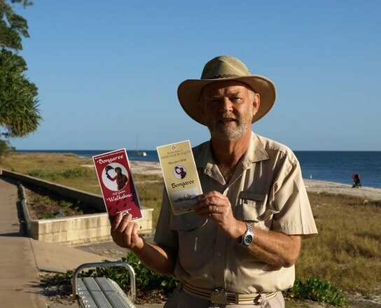
Barry Clark’s free Heritage Walk brochures available at Visitors Centre, Library and Museum.
The remaining individuals from various groups around Moreton Bay were dumped here on the island with basic provisions under government supervision. Not surprisingly, it created many social issues and soon closed down. A few years later, a school for aboriginal children was established at Mission Point.
Once again though, it proved an unsuitable site and the children were soon relocated to Stradbroke Island in 1892. What is believed to be the very first photo ever taken on Bribe Island records that event. In 1891 Bribie Island was briefly visited by Archibald Meston, an Explorer, Author, Politician, and the official “Protector of the Aborigines”. He made this comment… “Bribie Island is one of the meanest pieces of country in Australia… a howling desert of tea-tree swamps rank aquatic vegetation and unimaginable cussedness”
It is therefore quite remarkable that just 17 years later a group of Brisbane businessmen decided to invest significant sums of money, building steamships and leasing large areas of the island to develop Bribie into Australia’s first island holiday destination.
In 1912 the Brisbane Tug & Steamship Co. built a Jetty at Bongaree, and over the next few years saw the island develop as a destination for mass tourism, with many thousands of visitors coming by steamships every weekend and holiday, enjoying cheap and healthy holidays. More people came on camping holidays to Bribie Island than lived in the entire Caboolture Shire at the time.
These remarkable “boom” years for Bribie Island were however impacted in the 1930’s by the Great Depression, and soon after that came World War 2. These events led to great upheaval as the military moved in, most residents were moved out, and extensive defense structures were built on the island in 1942.
Some were removed after the war but many remain visible to this day. The “Steamship excursion” trips to the island resumed after the War, but by then the motor car was the popular form of transport, and increasing numbers braved the dreadful roads to the island. By 1963, a bridge had been built and the island was joined to mainland Australia. Looking back over more than 200 years since the first arrivals, our island has experienced many remarkable events, many of which can still be seen.
There are lots of things to look out for as you move around the island that provide clues to the past. Available at the Visitors Centre, the Library, and the Museum are free brochures for self-guided walks around interesting old buildings in Bongaree and the location of heritage plaques along the waterfront.
DID YOU KNOW THAT…
• There are over 50 Aboriginal sites officially gazetted on the Island, representing their occupation of this land over many thousands of years.
• The Water Tower in the Caravan Park at Bongaree is on the site of a large Aboriginal shell midden.
- The area known as “Red Beach” is a name carried over from the War Years when Australian and US troops did beach landing craft training at various colour coded beaches.
- Australia’s first Opera Australis was written by Emily Coungeau whose grand home, “Coungeau House” was built in 1915 and still stands in Banya Street, Bongaree.
- In the 1960’s, an Ionospheric Research Centre with an Atomic Clock was established on Bribie Island to study the behaviour of radio signals in the upper atmosphere.
- In the years 1914, 1932 and 1976 the residents of Bribie Island made three unsuccessful attempts to break away from Caboolture Shire and establish Bribie Island as its own shire.
Other Articles
https://thebribieislander.com.au/history-bribie-island-fascinating-history-historical-society/
